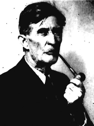
Arthur Coe Spencer
(1871-1964)

(Photo Credit: USGS Archives)
One day near the first of August 1900, A.C. Spencer found blocks of solid chalcocite, a mineral with about 80 per cent copper, in the talus slope he was climbing east of National Creek and Kennicott Glacier in Alaska’s Wrangell Mountains. Spencer was a U.S. Geological Survey (USGS) geologist on one of his first assignments in what would be a brilliant career. Spencer’s “discovery” was not the first at that talus field but it was an independent discovery and Spencer made it only a few days after the first finding by prospectors Clarence Warner and Jack Smith.
Warner and Smith knew only that their discovery was rich and significant. Spencer also knew that, but as he quickly deduced, he knew that the deposit had formed by a replacement of a massive limestone formation. Furthermore he was certain that the deposit was vein-like and that it cut sharply across the bedding some 50-ft above published his classic “The Juneau Gold Belt, the basal contact of the formation with a greenstone, an ancient and copper-rich basalt. It took at least another decade before most other geologists recognized the shape and orientation of the copper deposit—which was the Bonanza Lode of Kennecott Copper Corporation, one of the richest copper deposits ever discovered.1
Spencer was born September 27, 1871, in Mt. Carmel, New York. His parents were English immigrants, well educated and teachers in a young ladies seminary. Spencer who could claim to be chemist, geologist, hydrologist and general naturalist, graduated in metallurgy (B.S.) from Case School of Applied Science in Cleveland, Ohio in 1892. He worked during the summer months for the Iowa Geological Survey and earned a Ph.D. in geology from Johns Hopkins in 1896. Spencer and three other men, who also had major USGS careers, were the first geologists hired through civil service procedure by the Survey. The others were G. O. Smith, W.C. Mendenhall, both of whom were USGS Directors, and premier economic geologist F. L. Ransome. Spencer joined the USGS on September 1, 1896. Spencer worked for USGS until his retirement from the Survey at age 68 in 1939. After retirement from the Survey, Spencer consulted for the Bethlehem Steel Corporation and New Jersey Zinc. The New Jersey company hired Spencer “for his knowledge of Franklin Furnace, of hydrology, and his ability to inspire enthusiasm in younger men.”2
Spencer qualifies for Alaska Mining Hall of Fame on the strength of his work in the Wrangell Mountains and in the Juneau area. He began his Juneau studies of the rocks, structure, and ore deposits assisted by C. W. Wright in 1903, following topographic mapping in 1902 by W.J. Peters. Spencer Alaska” as USGS Bulletin 287 in 1906. Although productive throughout a government and later private consulting career, Spencer’s assessment as one of the great Survey geologists rests directly on five Geological Survey reports: Juneau, gold, in 1906; Cornwall, iron, Pennsylvania, in 1908; Franklin Furnace, zinc, New Jersey in 1910; Atlantic City, gold, Wyoming in 1916, and Ely, Nevada, copper in 1917 that were produced in a less than twenty year period.3 All of these reports were especially strong on alteration and chemistry.
Shortly after joining the Survey, Spencer was sent to Colorado where he worked with G.H. Girty and Whitman Cross in the southwestern part of the state. This was followed up with a war-time assignment in Cuba, where he served on the staff of military governor General Leonard Wood. Spencer’s Cuban Reports continued irregularly through 1918. In 1899 he was assigned to Alaska work, initially with Frank Schrader, where he made the Kennecott independent discovery.
Spencer’s Juneau work began in about 1903, and publications appeared as early as 1904, when he issued a preliminary report (USGS Bulletin 225) on the Juneau gold belt. In his final Juneau report in 1906 (Bulletin 287) Spencer described the Juneau gold belt as lying between 57 and 60 degrees north latitude and diagonally from 131 to 138 and beyond west longitude. The belt was noted as strongly linear and extending from Port Houghton on the south to the head of Lynn Canal on the north, with gold deposits scattered from Windham Bay on the south, through Juneau and Douglass island, to the Berner’s Bay area on the north. He recognized the great extension in depth of mineralization with a present 4,000 foot range of depth of mineralization at Juneau--not counting what must have been eroded. His chemical and alteration bent is especially evident in his work on the Treadwell deposits on Douglas Island where mineralization is mainly in strongly altered quartz diorite, converting them to albite diorite. In a paper published in the Bulletin of the American Institute of Mining Engineers (see list of publications) Spencer argued for a magmatic origin for the waters that formed the Treadwell deposits. Modern geologists, following USGS’s Richard Goldfarb, argue for a metamorphic origin, but the mineralized albite diorite with characterstic rutile and molybdenite at least looks like an igneous gold “porphyry” deposit.4 Spencer’s studies also included the gold placer deposits that were especially important in the early years of Juneau gold belt mining.

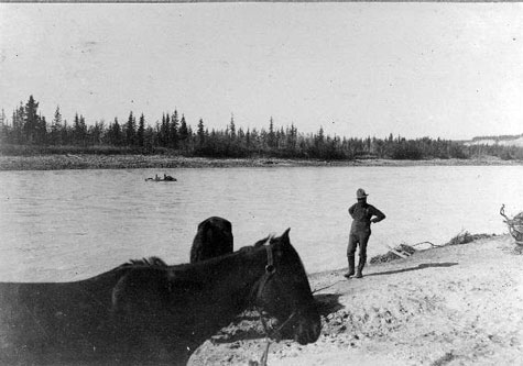
A.C. Spencer expedition fording the Chitina River, September, 1900
(Photo Credit: USGS Archives)
There is also somewhat of a mystery about Spencer’s work in Alaska and about his indirect influence’s to geology through the many young geologists who Spencer mentored. Spencer did not publish anything on Alaska after 1906, yet he spent the 1916 and 1926 field seasons in the Juneau district as shown through his unpublished field notebooks for those years.5 What did he do during those seasons? As yet there is no certain answer, but we know that the Survey made a new Juneau map at scale 1:24000 to augment earlier one-inch to the mile coverage during 1916.6 Where is the more detailed Juneau map? Possibly it was forgotten during intensive strategic work done by the Survey during WWI. A product of the 1926 work is also uncertain. Spencer’s 1926 field note books refer to work done near Berner’s Bay in the northern part of the Juneau district. and 1926 field seasons in the Juneau district as shown through his unpublished field notebooks for those years.5 What did he do during those seasons? As yet there is no certain answer, but we know that the Survey made a new Juneau map at scale 1:24000 to augment earlier one-inch to the mile coverage during 1916.6 Where is the more detailed Juneau map? Possibly it was forgotten during intensive strategic work done by the Survey during WWI. A product of the 1926 work is also uncertain. Spencer’s 1926 field note books refer to work done near Berner’s Bay in the northern part of the Juneau district.
Spencer’s last district paper was published in 1917. After that he seems to have devoted much of his official time in aiding younger Survey geologists.7 Geologist Bob Hoy noted that Spencer’s mentoring was so noted that it was parodied in a Pick and Hammer show:
“No longer can we go ask Spencer
What we may by intenser
Reflection might learn in a week.”
Like inductee Josiah Spurr, Spencer was small but wiry and with great stamina. He was a joy to be around. His admirer, Bob Hoy, an AMAX geologist, who wrote his GSA obituary, also recorded that:
“His humor is consistently excellent and in the best of taste . . . he seemed to have a never failing supply. Only on the rarest of occasions would he repeat. . . Everyone liked Spencer. He could become more intimate with most children in ten minutes than were their own fathers. He could be a bear on his back holding a pop bottle in the air with his paws and no one would think it was in any way out of the ordinary.”8
Spencer had a long and happy marriage to Elizabeth nee Lubin who died a year earlier than Arthur who was 93 years when he passed October 21, 1964, at Los Altos, CA. He left a son Oscar and a daughter Kathleen and six grand children.
Of all Alaskan USGS geologists, only a few approach Spencer’s brilliance. Of our inductees, possibly only John Beaver Mertie and Josiah Edward Spurr compare, the latter whose own intellect was at times wrong-headed.
Written by Charles Caldwell Hawley, October 26, 2013
Citations
1 Especially p.4, William O. Douglass, “A History of the Kennecott Mines, Kennecott, Alaska,” Alaska Division of Geological and Geophysical Surveys, Report MP-21, Reprint 1971. Douglass cites, F. C. Schrader and A.C.Spencer, The Geology and Mineral Resources of a portion of the Copper River District, USGS Special Publication, 1901.
2 Mainly from Robert B. Hoy, “Memorial to Arthur Coe Spencer (1871-1964.)” Geological Society of America, Bulletin v. 77, no.7, p139-144, quote on New Jersey Zinc, p142.
3 A.C. Spencer, The Juneau Gold Belt, Alaska. USGS Bulletin 287, esp. 3, 85-115; also ibid, Hoy, 141.
4 R.J. Goldfarb, USGS, Denver, Colorado
5 USGS Field Notes, 1916, from records supplied by Jill Schneider, current Alaska USGS
6 USGS Bulletin 662 on Mineral Industry Ak.
7 from A.H. Brooks summary article.
8 Hoy, ibid, 141.
9 Hoy, ibid, 140.
Alaskan Reports of A. C. Spencer
1901. “The physiography of the Copper River basin, Alaska.”Science, new series, v. 13, p. 189.________ (With F.C. Schrader), The Geology and Mineral Resources of a portion of the Copper River district, Alaska. USGS Special Publication, 94 pages
________1903. “Pacific Mountain system in British Colombia and Alaska.” Geol. Soc. America Bulletin, no. 213, p. 117-132.
________1904. The Juneau Gold Belt. Alaska. USGS Bulletin 225, p. 28-42.
________1906, The Juneau Gold Belt, USGS Bulletin 287. 115 pages